Google Maps introduces AI-powered “Ask Maps:” now you can talk to it
Google calls the changes the “biggest navigation upgrade in over a decade.”

Driver touching screen of navigation system. Nico De Pasquale Photography/Getty
Google calls the changes the “biggest navigation upgrade in over a decade.”
- The new "Ask Maps" feature lets drivers ask complex, natural-language questions, like where to charge a phone without a coffee line.
- Responses draw from your search history, saved places, and 500 million user reviews to personalize recommendations
- Immersive Navigation blends Street View imagery with aerial photos, showing building heights, highlighted lanes, and real-time hazards to help drivers prep for tricky maneuvers.
Key Takeaways by nexos.ai, reviewed by Cybernews staff.
Google has introduced two new features: Ask Maps and Immersive Navigation. According to the company, the purpose of both tools is to make driving “more intuitive” and conversational.
In practice, this means that Ask Maps will be able to hold a conversation with the driver and give answers.
“My phone is dying – where can I charge it without having to wait in a long line for coffee?” is one of the conversation examples the company provides in its blog post.


Previously, if users were interested in this kind of information, they had to research the question and browse other people's reviews. The new feature lets users tap the “Ask Maps” button to have their questions answered as if in a conversation.
According to Google, the answers should come tailored “based on the information the company already has on the users, such as places they’ve searched in the past or had saved in Maps.
The answers should also include directions with recommendations drawn from over 300 million locations and more than 500 million other user reviews.
“My friends are coming from Midtown East to meet me after work. Any spots with a cozy aesthetic and a table for 4 at 7 tonight?” Ask Maps already knows you like vegan restaurants and finds convenient midway spots with vegan options,” claims the company.
Ask Maps will launch first on mobile devices in the US and India, with a desktop version expected soon.
Meanwhile, Immersive Navigation is designed to enhance the journey with 3D visuals.
The new feature combines real-life Street View images with aerial photos. As a result, drivers can see not only the regular squares and rectangles that represent buildings, but also their heights, trees near them, highlighted lanes, traffic signals, and landmarks.
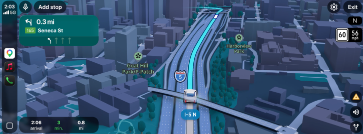
“Smart zooms and transparent buildings help you look ahead to prepare you for tricky turns, and lane changes well in advance,” says Google.
The system will also alert drivers to roadworks or accidents. This information will also come from a network of other system users who report on issues they see on the road. That’s more than 10 million active contributors.
Immersive Navigation will roll out gradually across the US, supporting Android, iOS, CarPlay, Android Auto, and vehicles with Google built-in.
Unlock more exclusive Cybernews content on YouTube.