Satellites reveal Greenland ice loss as high as a skyscraper
The first-ever joint ESA and NASA satellite pictures show devastating ice disappearance in Greenland, once again proving that climate change is a serious issue.

Image by Cybernews
The first-ever joint ESA and NASA satellite pictures show devastating ice disappearance in Greenland, once again proving that climate change is a serious issue.
Many climate scientists are bracing themselves as Trump has taken his second term, leaving uncertainty about climate change policies and the US stance on the Paris Climate Agreement.
The president-elect expressed his strong skepticism towards climate issues and continued to attack climate action and science throughout his campaign, with such slogans as “drill, baby, drill.”
During his first term, Trump rolled back climate regulations and withdrew the US from the Paris Agreement—a step he has vowed to take again.
However, despite political skepticism, there is more scientific proof —the world’s ice sheet is melting at a rapid pace, and modern space technologies can help monitor it with high precision.


ESA’s and NASA’s satellites reveal Greenland is defrosting
Academics from Northumbria University have just released their latest research, which uses data from satellites to track changes in the thickness of the Greenland Ice Sheet.
Global warming is causing the ice sheet to melt and flow more rapidly, raising sea levels and disturbing weather patterns across the planet, which have far-reaching impacts on ecosystems and communities worldwide.
Over the 13-year research period between 2010 and 2023, satellites captured the ice sheet diminishing by 2,347 cubic kilometers—an amount large enough to fill Africa’s Lake Victoria.
The Greenland ice sheet has thinned by an average of 1.2 meters. The most dramatic thinning occurred at outlet glaciers, many of which are accelerating.
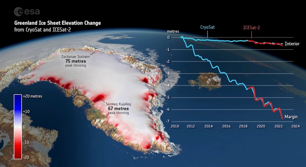
At Sermeq Kujalleq (Jakobshavn Isbrae) in west-central Greenland, peak thinning reached 67 meters, while at Zachariae Isstrom in the northeast, it peaked at 75 meters.
The most significant changes were recorded in 2012 and 2019, years marked by exceptionally high summer temperatures when the ice sheet lost over 400 cubic kilometers of its volume annually.
Satellites bring in precision
Scientists have delivered the first measurements of the change in thickness of the Greenland Ice Sheet using CryoSat-2 and ICESat-2, the ESA and NASA ice satellite missions.
Both satellites complement each other. CryoSat-2 carries a radar system to determine the Earth’s surface height, while ICESat-2 has a laser system used for the same task.
Radar signals can pass through clouds and penetrate the ice sheet surface. Laser signals, on the other hand, reflect from the actual surface, but they cannot operate when clouds are present.
Research published in Geophysical Research Letters confirms that these satellites can be combined to produce a more reliable estimate of ice loss than either could achieve alone. It also means that if one mission were to fail, the other could be relied upon to maintain the record of polar ice change.
“Their complementary nature provides a strong motivation to combine the data sets to produce improved estimates of ice sheet volume and mass changes. As ice sheet mass loss is a key contributor to global sea level rise, this is incredibly useful for the scientific community and policymakers,” said lead author Nitin Ravinder.
Scientists believe that having access to accurate, up-to-date data on ice sheet changes will be crucial for helping humanity prepare for and adapt to the effects of climate change.